
TL;DR (the short version)
Auckland Transport plans to build protected bike lanes on Carrington Road (good), but will lower the Northwestern path crossing back to how it was pre-2019 (not good).
We need you to show your support for keeping the crossing raised – and bringing all the other proposed changes up to scratch.
Find out more here and drop a pin on the feedback map by Sunday 23rd June.
What is this project?
Carrington Road is the key connection between Pt Chevalier and Mt Albert, and over the next few years will have 4,000 new homes added to the Carrington Residential Development (on the old Unitec site). With this new housing comes government funding – $122 million – to upgrade the whole corridor.
The goal is to give both old and new residents more travel options – by adding bus lanes, proper protected bike lanes, more crossing points, and more greenery along the way. Here’s how Auckland Transport describes the expected outcomes:
- Safety: Carrington Road should be safe for everyone.
- User experience: Getting from A to B on Carrington Road should be a positive experience, however people travel.
- Travel choice, connections, access: People should have options for how they travel, wherever they want to go and whatever their age or ability.
- Liveability, wellbeing, environment: Carrington Road should be designed to be sustainable and adaptable to change.
They’re currently asking for feedback on their preferred design. You can have your say by pinning your comments on the map here.
You can also email questions or thoughts to the team at ATEngagement@at.govt.nz

Why is it important?
The project will provide safer all-ages cycling along the whole of Carrington Road, upgrading the current painted lanes to protected ones. At the north end, these will tie into the protected cycleways now under construction through Pt Chevalier to Westmere.
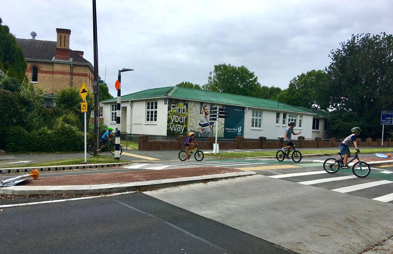
Also, the busy Northwestern shared path crosses Carrington Road via a raised crossing. Auckland Transport tells us this crossing is currently used by around a thousand people on bikes per day between 6am-6pm, and 75% of those are travelling east-west, i.e. continuing on the shared path.
Moreover, their modelling says total bike journeys in this area will triple in coming years, with bike movements across this crossing rising to 1700 per day by 2028, and 2100 per day by 2038. That’s a lot of people – and that’s not even counting pedestrians and other kinds of mobility.
Besides accommodating the expected growth on the Northwestern path and the local cycle network, this design needs to be future-proofed for everyone who’ll be moving around this area on foot or on wheels.
As well as thousands of new residents in the Carrington development, there are dozens of new Kāinga Ora builds in Point Chevalier and Mt Albert (including the John A Lee apartments, for people 55 and older), and wheelchair-accessible housing on Segar Ave.
Love what we do? Join the Movement for a Better Region on Bikes!
Already, hundreds of children go to schools and daycares along Carrington Road and at each end. Add in all the people shopping at town centres to the north and south, and the passengers of the frequent buses, who need to cross the road safely, and everyone walking or biking to the two nearby train stations.
A historical note: Did you know Carrington Road was the first street in Auckland to get modern painted on-road bike lanes, in 1999? It’s a measure of progress that it’s finally gaining properly protected lanes, two and half decades after the painted ones went in!

The design
The good news: Auckland Transport (AT) has listened to feedback from the last consultation and has opted for one-way cycleways on each side of the road. These will be protected by a mixture of concrete tim-tams and planted buffers, with rubber “orcas” around driveways.

Also, the bus stops will be “floating” stops, i.e. the bike path is routed safely around them. This means people on bikes won’t have to play leapfrog with buses any more, and gives bus passengers and people on bikes their own separate spaces.
The design also adds traffic lights and crossings to key intersections, plus additional crossing points for people on feet and wheels.
Raise your voice to keep the Northwestern crossing raised!
This is our big ask. We strongly encourage you to give feedback on the whole corridor – but if you just have time to put one pin on the map, this is it.
The Northwestern shared path crosses Carrington Road, on a raised crossing. This used to be a plain zebra at street level, and was upgraded to a raised dual pedestrian-bike crossing in 2019 after much lobbying by locals as well as Bike Auckland.
As one of the hundreds of people who uses this crossing daily, it’s impossible to overstate the safety improvements from raising this crossing. In the before times, you were never quite sure whether a car would stop. This insecurity resulted in delaying “will-they-won’t-they” games on good days, hair-raising near-misses on most days, and some serious injuries to vulnerable travellers on bad days.
Raising this crossing hasn’t completely eliminated near misses and crashes, but speeds are now significantly lower, meaning that if the worst happens, your chance of walking away from a crash is significantly higher.
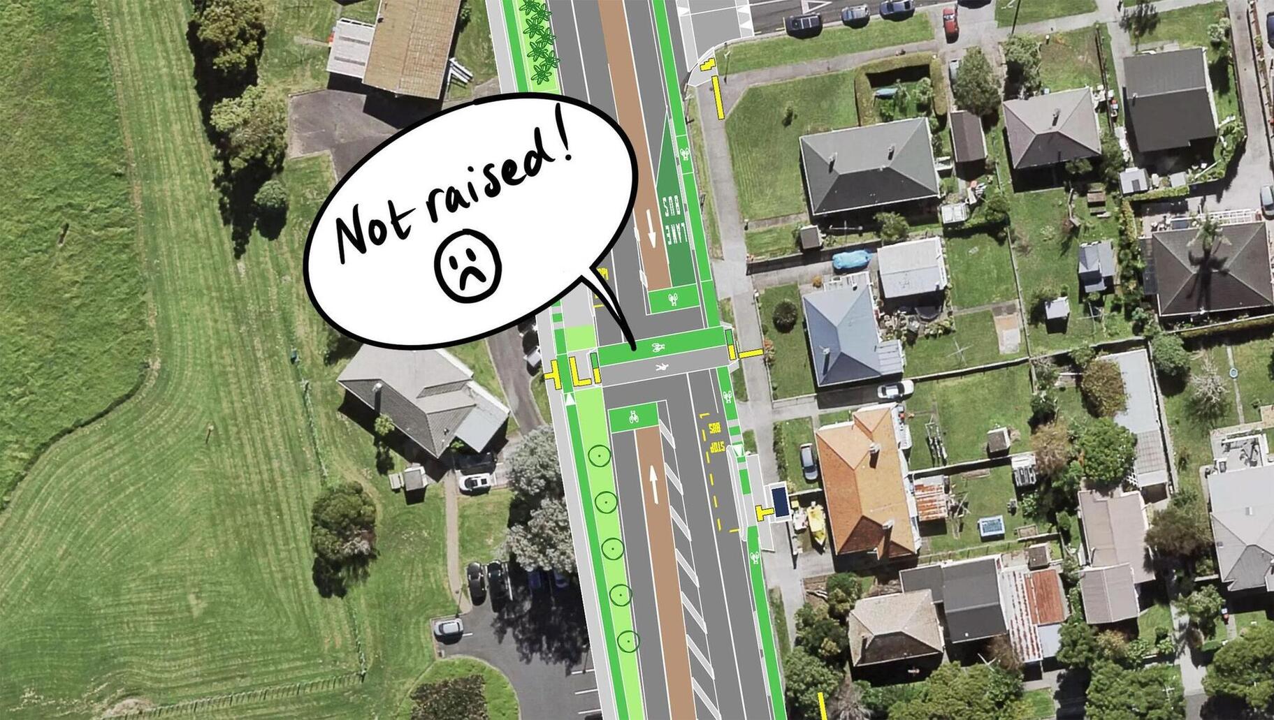
Bike Auckland and others were recently involved in providing extra feedback about this crossing, because the proposed design shifts it slightly north of its current location.
The proposed move means less of a switchback for people travelling west-east and vice versa. The other good news is that the new crossing will still only cross two lanes of traffic, which means it can stay as a zebra rather than needing traffic signals. We are pleased with this.
However: recent directives from the Mayor and the Minister of Transport have led Auckland Transport to conclude they shouldn’t have raised crossings on “arterials” – even where it involves a cycling “arterial”.
As a result, they propose to lower this crossing back to street level, a shockingly unprecedented move that would dramatically reduce safety for everyone.
UNLESS, it seems, there’s significant community support for keeping it raised.
So, even if you leave no other feedback, please add a pin on the feedback map to show your support for keeping this crossing raised.
Other things to consider at this new location for the Northwest crossing: how will people biking west-east and vice versa navigate the entrance of Sutherland Road?
How will the shared path on the corner outside the childcare centre cope with the extra foot and wheeled traffic?
How will southbound cyclists on Carrington Road access the Northwestern Path, whether heading westward to Te Atatū and beyond, or east into the city?
Does it make sense for the green bike crossing to be north of the striped zebra for pedestrians? Would it make sense to have two green stripes either side?
Your experiences and thoughts here are important – add them to the pin-drop map!

A closer look at the details, going south to north
The Mt Albert rail bridge has seen some recent interim improvements, as mitigation for closing the nearby Lloyd Ave pedestrian crossing of the railway lines. There are now rubber protectors for the painted bike lane on the station side, and the eastern path (on the city side) has been widened into a sort-of shared path.
The plan is unclear here: Auckland Transport says it’s weighing up widening the east side bridge, versus “other options”. We say everyone deserves better space for walking and cycling on both sides, and smarter, safer access to the train station.
Suggestion: Support a full quality redesign of this bridge. You could also note the need for safe links through the New North Road intersection.

North of the railway line, parking will be removed along the west side of Carrington Road between Wilcott and Woodward to allow for a continuous protected cycle lane. This is an easy one to support!

The intersection of Woodward Road will get traffic lights and controlled crossings. This is good news for anyone who, like me, has been riding downhill along Carrington Road towards this junction, only to have a car pull out at the last second.
One fish-hook: on the southwest corner of this intersection, a pavement build-out accommodates a couple of property driveways. At the moment, it’s a no-exit area that’s used as de facto parking. However, in the new design, it looks like cars will be able to drive in from Carrington and out onto Woodward.
Drivers who are tempted to use this as a short-cut around the traffic lights would be zipping across the bike lane and pedestrian desire line – not a safe combination.
We suggest: ask for design measures to stop drivers using this as a slip-lane shortcut to Woodward Road.

At Unitec’s main entrance (opposite Seaview Terrace), the current light-controlled intersection gains a welcome new crossing leg for pedestrians, and the left-turn slip lane is deleted.
This intersection is and will be heavily used by Gladstone Primary School kids and families crossing on foot and on bikes. With two lanes coming out of Unitec, we think the wide mouth of the side road needs designing for children’s safety. (We’re also curious about the plan for safe cycle access into Unitec, but that’s out of scope for this design).
We suggest: ask for better safety at this key crossing for children on feet and wheels.

Farm Road, which leads to Unitec’s Te Noho Kotahitanga marae, will get new traffic lights. You might have spotted the fresh two-way cycleway here, towards the future housing – a glimpse of how all main streets in the new development will look.
This poses a design challenge: how best to connect these bi-directional cycleways with the uni-directional ones on Carrington Road?

Between Fontenoy St and Tasman Ave (both of which give handy access to Baldwin Ave train station), there will be a new dual crossing for bikes and pedestrians. This will link to a planned greenspace plaza in the residential development.
This crossing is not planned to be raised, seemingly due to recent public statements by elected leaders. However, this is not in line with Auckland Transport’s own design guide and its research on the safety benefits of raised crossings.
We suggest: ask that this crossing be raised to improve safety. (The same applies to the new crossing north of Prospero Terrace)
“Gate One”, the northernmost access to the (former) Unitec site, has shifted slightly to the north, and is being widened to accommodate bus and traffic lanes, as well as the new cycleways.
Again, you might want to ask about how the internal two-way bike lanes will connect to the one-way lanes on Carrington Road.

We’ve covered the Northwestern crossing above – but don’t forget to add your support for keeping it raised!
At the north end of Carrington Road, on SH16 motorway overbridge, the protected bike lane on the east side remains, and a new one will be added on the west side.
However, the western-side bike lane stops short of the intersection and melts back into a shared path, which shrinks down to a dodgy pinch point in the middle. People heading to Point Chevalier will need to cross a slip lane crossing to the small refuge island.
At this busy intersection, the connections between the Carrington Road cycleways and the Point Chevalier Road cycleways will need to be easy, safe, accessible and as intuitive as possible for all ages, abilities, and kinds of bike.
We suggest: ask for a smoother and safer connection between these two cycleway projects at this major intersection. The approach should be wide enough for safety at the motorway overbridge, with ample waiting room at the intersection for both bikes and pedestrians. If the slip lane must stay, the crossing should be raised, for maximum visibility and safety.

Side-street crossings
The side road treatments are not very consistent. For example:
- There are raised tables on each street on the east side, but not at the Rehab Plus driveway north of Segar Ave, which is just as wide as the other roads.
- The Gate 2 intersection (opposite Segar Ave) has a painted zebra on the raised table, but that’s the only one! Auckland Transport’s own Design Manual says to “consider pedestrian crossings across side roads [to] increase safety and accessibility”.
- Prospero Terrace has a new speed bump as part of the Lloyd Ave crossing mitigation, but it should be a raised table and better positioned to match the other side streets.

We suggest: ask for proper zebras on raised tables across all side streets and major driveways, for safety and visibility for people walking, scooting and rolling. Any extra tricks to prevent drivers from sitting across the cycle lane as they try to turn from side streets into Carrington Rd would also be welcome.
Intersection designs
The proposed intersections are complicated, especially as the uni-directional bike lanes on Carrington Road need to join up with bi-directional lanes in the new development.
On the plans, each intersection seems to have a missing leg for bikes. Given that most are T-junctions, this could be okay, depending on the light phasing (a bike Barnes Dance?). Note there are also painted advance bike boxes at the head of some traffic lanes, as an option for anyone who prefers to cycle on the road.
This combination may cause confusion. For people using the protected bike lanes, if you want to turn right, are you meant to pop out of the protected lanes, tiptoe across to the painted box in front of the cars, and wait for a right-turn arrow?
If the intention is for people to make a “hook turn” (as shown in pink below), this should be made very clear by road markings or signage.

Alternatively, Auckland Transport could take a look at its Transport Design Manual for other ways to design these intersections.

(Protected Signalised Intersection pp 174-5)
We suggest: point out any concerns with bike movements at the intersections, and ask for a design that prioritises legibility and safety.
(Neighbourhood Collector Street pp152-3)


