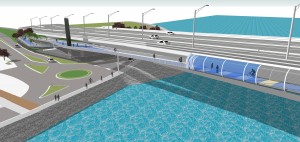
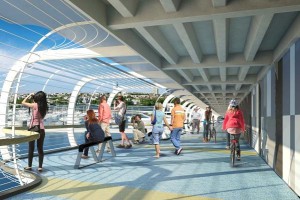
 We were as excited as anyone when the AHB Pathway Trust team lodged their resource consents for SkyPath last month. The jewel in the crown of Auckland’s walking and cycling network is rapidly approaching a reality, and we can’t wait! Even John Key‘s keen to get a cycle path over the Harbour Bridge.
So it’s timely to discuss how people will connect with SkyPath, and what they’ll do. This post looks at the northern end, with a focus on cyclists of course, but not forgetting our walking friends who are just as excited as we are. And the southern side? We’ll post on this too in due course.
So who’s going to use SkyPath? Your immediate response might be commuters, and you’d be partly right. We expect not just existing cyclists who queue up at the ferry terminals every morning, but many North Shore residents will be lured from their cars with the promise of a cheap, healthy, scenic, stress-free and congestion-free trip to town and back home again.

But if you look at the research conducted by the Trust, they predict tourists and recreational users will outweigh commuters by four to one! That’s huge, and it begs the question – where are these people going to go,and how are they going to get there?
This post will focus on recreational SkyPath users who find themselves in Auckland City, making their way north across SkyPath, and landing in Northcote Point. What are their options, and how can we best cater for them? What route are they going to take to return to the city?
The stars on the map show local attractions that are easily accessible by bike or on foot. We haven’t extended too far beyond Northcote and Birkenhead nor have we dwelt on the attractions of Takapuna and the Devonport peninsula – they’re pretty obvious.
Looking at Northcote and Birkenhead, the primary attractions for tourists and recreational users are:
- Cafes and associated eateries, perhaps even a movie
- Beach, playgrounds and bush walks
- Heritage appreciation
- Shopping opportunities at the vibrant multi-cultural Northcote Shopping Centre, or the trendy shops in Birkenhead and associated Highbury Centre.
So what routes do we need to promote and enhance to make this both a safe and pleasant experience for pedestrians and cyclists, and provide commercial opportunities for businesses close to potential paths? Let’s take them in turn, from west to east.
The immediate return trip
Ok – we’ve done SkyPath, now we want to go straight back again. So either back through the turnstiles, or even better a wander around the fascinating Harbour Bridge superstructure, taking in the city views from Stokes Point Reserve, then down a path to the Northcote Point ferry terminal for a cruise back to the city.
The only requirement here is for the path between the SkyPath terminus and the ferry terminal be suitable for cyclists, pedestrians, and the mobility-impaired.
The walking route to the Birkenhead ferry via Little Shoal Bay
Nothing much to be done here as the footpaths are already in place. Cyclists can use a variation of this route too, but many recreational cyclists will find the Council Tce/Maritime Tce hills a bit of a challenge. The cafes and shops of Northcote Point and lower Hinemoa St are within easy reach of this route.

Cyclist route via Onewa Rd
The Northcote Safe Cycle Route comes into its own here, providing protected cycle lanes all the way to Onewa Rd, although many will choose to dog-leg through Faulkeners Rd and Church St to miss the big Lake/Queen intersection. But Onewa Rd? Isn’t that a heavily trafficked main road with no cycling infrastructure? Yes – it is at the moment, but here’s the plan.
AT is planning a westbound T3 transit lane to cater for the afternoon peak, but to do so would make the uphill westbound trip difficult and hazardous for even experienced on-road cyclists. So part of the plan is to create a shared path along the southern side. Cycle Action has previously endorsed this approach, and has also proposed the same treatment be applied to the northern side as well for eastbound cyclists.
So the requirement here is for shared paths on both sides of Onewa Rd, with additional consideration for the Church St leg.
Cyclist route from Highbury to the Birkenhead ferry terminal
The future of this route hinges on the plans for the renovation of the Birkenhead Town Centre, which will significantly improve pedestrian and cyclist safety around Birkenhead Ave, Mokoia Rd and Hinemoa St. How Hinemoa St is treated, and the extent to which the works go will determine the best option for the remainder of the route to the Birkenhead ferry terminal. Options could include traffic calming (perhaps with a reduced speed limit and sharrows), the removal of pinch points around the cafe area where parked cars constrict the roadway at raised central medians, shared paths or buffered cycle lanes.
Northern route to Northcote shops and northern Takapuna
Here the Northcote Safe Cycle Route is the perfect answer. Thanks AT!
The AUT connector
With more of a commuter focus now, we need a connector from the Northcote Safe Cycle Route to AUT, both as a route for students, but also anyone who may choose to park in the paid-parking of the AUT campus. The route will also service Awataha Marae, opening up the possibility of cultural experiences for tourists.

The requirement here will be for buffered cycle lanes along College Rd, which will require the loss of some on-street parking, as the road is quite narrow in places. However with the proximity of parking at both the Northcote Shopping Centre and AUT, this should not be too much of a problem. Indeed at the northern end, it is mostly AUT students who park for free on College Rd rather than the paid-parking on campus.
Another local initiative here is a cycle path in the vicinity of Onepoto Primary School and Tonar St, which will likely develop with the Kaipatiki Local Board’s Network Connections plan.
Akoranga Drive/Esmonde Rd shared path
The existing shared path is adequate, but could be much improved. It went in years ago when the Esmonde Rd interchange was created, at a time when shared paths were tacked on as an afterthought. But it doesn’t require much to improve it – prioritisation across the side roads coupled with specific cycle/pedestrian signals would do the trick. A bit of sweeping every now and then would help too – funny how those concrete walls attract bottle-throwing hoons.
SeaPath
Which brings us to SeaPath, the connector to southern Takapuna and the Devonport Peninsula. This route is currently being considered by NZTA, as much of it sits in the motorway corridor. The route shown on the map is only approximate. It hasn’t yet been decided exactly how and on which side of the motorway SeaPath should run, and whether it should connect up to Warehouse Way or continue along the exit ramp to Esmonde Rd. We’ve asked NZTA and Reset Urban Design who are working with them on it, but they haven’t shared their thoughts with us yet. We’re all ears.
What we do know:
- With its proximity to the harbour edge and Tuff crater, the path is going to be an exceptional attraction in its own right
- It needs to be plenty wide, perhaps 5 metres, to cater for the large number of cyclists and pedestrians who will be using it
- Gradients need to be gentle, so it needs to follow the motorway corridor as much as possible
- Some of the area is ecologically sensitive. The Herald article from 12 years ago reminds us just what an issue this is.
And it’s with ecology in mind that Forest and Bird are promoting NaturePath, their preferred variant of SeaPath. We’ll take a look at NaturePath in a future post, but at first glance it’s certainly got merit.
Bus, ferry and cycling integration options
For some SkyPath users, a bus service between the Northern Busway Stations and the Birkenhead & Northcote Point ferry terminals would be a welcome addition. To this end we would suggest:
- A reasonably frequent service of small to medium sized shuttle buses, equipped with bike racks. There have been a number of trials of the “bikes on buses” concept, including as close as Waiheke Island, and we see no reason why it can’t be introduced here
- Increased frequency of Fullers ferry sailings on the Birkenhead/Northcote Point route, particularly in the weekends when recreational use of SkyPath will be higher.
Taking this concept a little further as a tourist opportunity, Fullers could sell a “tourist pass” which encompasses a trip over the bridge with a ferry ride, and perhaps an inter-linking bus to Birkenhead via Onewa Rd with multiple drop-off and pick-up points at no extra charge. Perhaps hire bikes could be included to the mix as well.
And needless to say, the businesses wanting to most benefit from increased cyclist patronage will provide secure bike racks adjacent to their premises!
Summary
So in summary, SkyPath is much more than a route for commuter cyclists. It will be a major tourism and recreational opportunity, with the potential to breathe new life into businesses in the Northcote/Birkenhead area, and further afield to Beach Haven, Glenfield, Takapuna and Devonport for those who wish to travel further.
We’d like your feedback on the suggestions made in this post, so we can integrate them with stakeholder sessions we’ll be having with the Trust, NZTA and AT. Fire away, but please limit your comments to constructive suggestions on how we can make a great initiative even better. We’re aware there are some who are opposed to SkyPath and the Northcote Safe Cycle Route. This is not the forum to relitigate those opinions.
Give us your ideas and feedback…


