In this short series, we discuss [not necessarily in order of importance] the various Auckland cycle projects that have achieved funding from the Urban Cycleway Fund, and thus are likely to be built in the next 3 years.

The Waterview Shared Path was pretty controversial in its time. As you can see from past blogs (1, 2) on our website, it wasn’t easy convincing decisionmakers to include it, and in the end, it fell to the Board of Inquiry making a judgement on NZTA’s efforts to mitigate their big motorway project.
Happily, a number of major walking and cycling improvements were finally ordered by the court as part of the mitigation package, including a new path between the New Windsor / Owairaka paths and the Northwestern Cycleway in Waterview / Point Chevalier.
But we can hear you say: “What does that have to do with the UCF money – surely the Waterview Cycleway was funded separately? And where the heck is it anyway – you’ve been talking about that one for years!”
Yes, and yes. Construction has been delayed a lot longer than we would like, due to the project not being included in the original consents for the motorway (the latest target is to have it ready by the end of 2016 – pending consents for which the hearing finished in June, with a decision due soon). But even before being built, it is starting to have exactly the effect we had hoped – forming a new backbone and becoming a springboard for other projects.
One of the ideas suggested by the local boards at the time was to take the new Waterview shared path plan, and marry it up with old plans (sleeping away on Council shelves) to make a start on a cycleway along the Western Rail Line. So, when Auckland Transport went away to start design work on the “tunnel cycleway”, they also included investigation of a “spur line” linking to Avondale and New Lynn.
This is the project that has now received funding from the UCF.

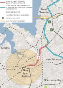
CAA has had a bit of input into the project over the last year or so. It starts branching off on the western side of the future Soljak Place bridge (built as part of the Waterview path), and then runs along the northern side of the rail line over a deep gully to Trent Street and the Avondale Train Station. From there, it keeps following the rail line (it will likely have to switch sides at least once or twice, due to property constraints), crossing the Whau River “headwaters” north of Olympic Park, before ending up in the heart of New Lynn next to the train station.
The path will offer a lot of use for longer-distance riders as well as short trips for locals and easy bike trips to various train stations. Cycling into the City Centre from New Lynn will be as doable as from Te Atatu. The town centres of New Lynn and Avondale will be much easier to get to from each other (currrently anyone wanting to walk or cycle here has little choice except Great North Road, or Wolverton St, neither being a particularly pleasant route). Many more residential areas will now be much “closer” to their nearest train station too.
Of course, it’s still a backbone route, and what use are backbones without arms and hands attached? So we’re keen to see local groups and local boards jump onto this proposal. Join the call for better local streets, greenways and slow-speed zones to make the most of these new routes. It’s only natural for big projects like this to get the limelight – but they will only be really successful if they start to branch out.


