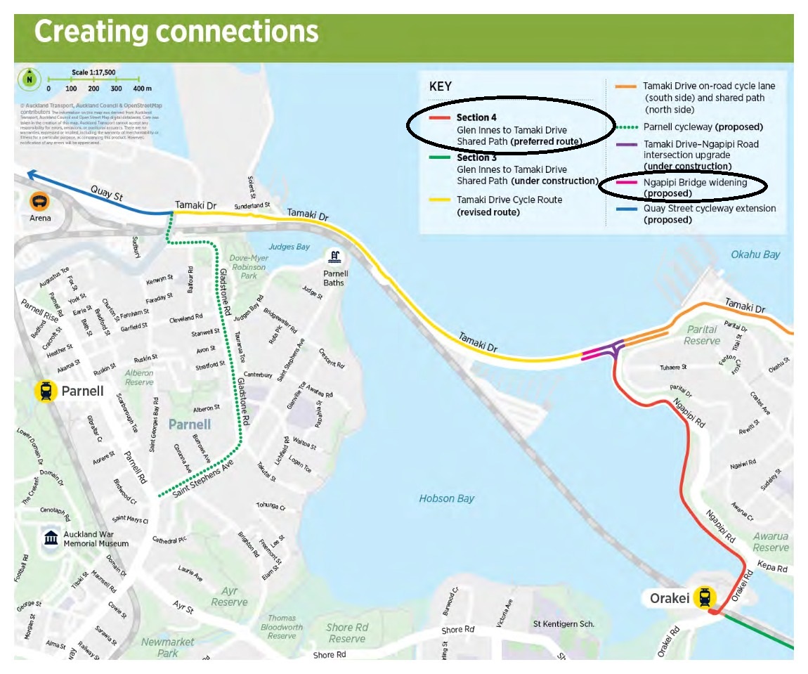
As you will probably have read in our Tamaki Drive jubilation blog, a lot of big decisions are currently being made on cycleways in the Orakei area.
Hot on the (w)heels of the decision that Tamaki Drive between Solent Street and Ngapipi Road would get a proper, protected two-way cycleway on the north side, AT have now opened consultation on two other items, both closing 8th October.
- The last section of Stage 4 of the route from Glen Innes to Tamaki Drive, and
- The new Ngapipi Bridge (which, despite the name, is the outlet bridge on Tamaki Drive just west of Ngapipi) – see blog post on that here.
Please consider giving feedback on both!
Read on for our key suggestions on the Ngapipi boardwalk route, and a more detailed analysis below that…
GI2TD Stage 4 – the Ngapipi Route: the quick feedback guide
Link to the feedback form
Q: What do you think of the route?
- We support the route – it’s not perfect but it does the job. It connects the network well in the face of significant constraints of money, time and space.
Q: How would you improve it?
- So it works for transport riders, curves should be as generous as possible so as to ensure reasonably consistent speeds. Particularly where Stage 3-to-Stage 4 curves up under the rail line onto Orakei Rd, or where it turns left at the Kepa Road intersection.
- A good non-slip surface is crucial, as the boardwalk will be under trees and in shade for part of the day. This could be a composite material, or even asphalt or concrete (after all, a boardwalk is really just a long, low bridge…).
- At the boat sheds, maximise space while retaining parking and loading (to avoid conflicts), perhaps by narrowing the road and moving it slightly closer to the cliff. This will hopefully allow up to ~8m width for the Stage 4 path and boat shed parking/loading.
- At the Tamaki Drive intersection, the space in the central island needs to be larger, with minimal signal delays for cyclists crossing Tamaki Drive. This should be possible by adjusting the consented design slightly.
Q: Any other comments or suggestions?
- Add here any other comments you may have on the route.
Let’s take a closer look…
Route overview
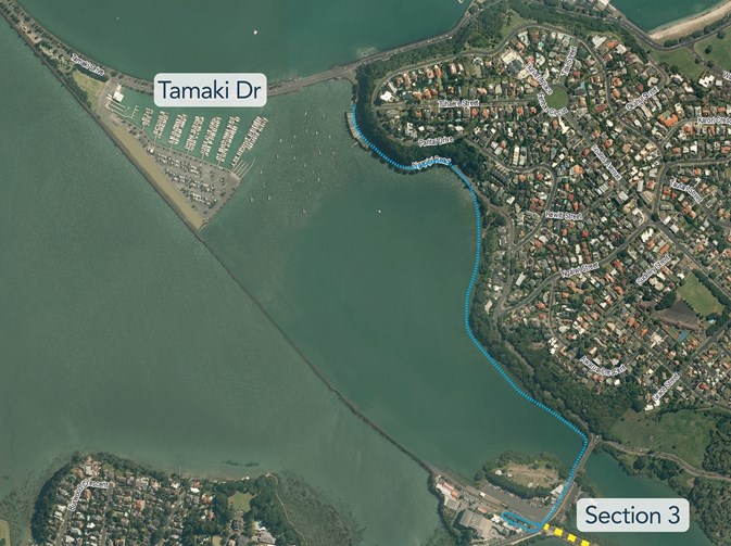
The proposed route for Stage 4 of the Glen Innes to Tamaki Drive path will run from the end of Stage 3 (the existing boardwalk, which is being widened) under Orakei Road. It will loop up on the west side near the train station (similar to, but better and wider than the existing ramp). Then it will follow the western side of Orakei Road to near the Kepa Road intersection, using a widened bridge. From there, it will drop down to near the water level, and hug the coastline as a boardwalk until shortly before the boatshed area at the top of Ngapipi Rd, where it will transition back to land, running parallel to the road.
See full project details on the AT website.
How we got here
As we’ve written, the decision about this section wasn’t easy, and it isn’t the perfect solution for a perfect world. Most of us – including Bike Auckland – would have preferred a run straight across the bay along the rail line, maybe with an iconic fly-over bike bridge to land us on the northern side of Tamaki Drive. This would have been some 700m shorter for those heading towards the city, too.
If you’re keen to understand the in-depth thinking that ruled out the other options, there’s extensive documentation of the multi-criteria analysis on AT’s project page. We won’t get into that here, but one thing to note is that the other options were more expensive – by several million dollars – than the final one. Funding is tight; we understand that construction costs for AT have risen 20-30% in 3 years as all the contractors are busy, and the current funding runs out in 2018, with no certainty of being held over for later or renewed in future. (Reminder: it’s election time – look here for the parties’ policies on biking, especially funding).
Additionally, the route across the bay had significant property issues at the OBC marina; contrary to earlier perceptions, the land next to the rail corridor was indeed legally theirs to use. So the only viable options left through that area included significant boardwalks cantilevered above the OBC land or their marina entrance, driving the costs even higher in an already over-subscribed budget.
There was a real risk that if no sensible option had been found, the whole project could have failed – or been delayed for many years (it’s already behind schedule). This would have included risks for Stage 2 and 3 to the east, as a consequence of the uncertainty about not having a full connection to the city.
So, given these constraints, we feel that the Ngapipi Drive option is a more than simply adequate choice. The straight-run vista across the bay is replaced with a sheltered ride under pohutakawa trees. The extra distance is somewhat balanced out by a more direct route to the eastern bays for some riders, and a more direct connection for all users to a viable crossing point to Tamaki Drive’s northern-side two-way paths.
Where to now?
So, what does Bike Auckland feel can be improved? Our summary above gives the gist – the path should be as safe and useful as possible.
This starts with ensuring smooth curves where the path goes up to and down from Orakei Road (near Orakei Peninsula), allowing you to actually ride those switchbacks and 90-degree curves without coming to an almost dead stop. This is a matter for detailed design, but raising it as an issue now will put it into AT’s minds.
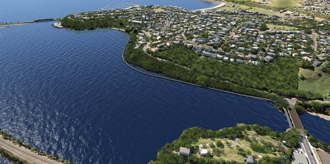
On the positive side, while the route itself may look a bit curvy in general, those sweeping coastal curves are actually pretty generous – no real riding constraint for most of the route.
Some have asked why the route hugs the curves and doesn’t run diagonally out across the last bit of the bay towards Tamaki Drive?
We understand that moving that far away from the coastline adds a whole lot of planning approval risk (a ‘get in the sea’ situation, so to speak), and also makes the path more obtrusive (like a new causeway) from various vantage points, creating a risk of resistance from locals and boat owners.
The next matter that will need close attention is the boardwalk surface. It will get a lot of morning shade, and will have trees above it – so how to avoid the surface being slippery? Don’t be too worried by the word board-walk. It’s pretty unlikely that the surface itself will be wood, and even if it is, it will be specially treated. More likely, it might be a totally different surface material (still to be determined). But it’s certainly an important point for users.
One remaining item for concern is how the path passes the boat sheds west of Ngapipi Road, as it approaches Tamaki Drive. We know that some boat shed owners are concerned about the path, and what it may mean for their access and parking.
We’re the advocates, not the designers, but looking at the existing cross-section near the sheds, we feel that there is actually quite a bit of width here – something on the order of 16m or so. Maybe more, if the ditch drain on the eastern side can be changed to a piped stormwater line to move the road closer to the cliff face. So even if half of that 16m needs to be given to the road (which carries buses and over-dimension vehicles to and from the Ports of Auckland), there seems to be a lot of space to keep the boat shed parallel parking, and fit in a safe and wide shared path as well.
The last item – and one that concerned a lot of users at our open day evening with AT two weeks ago – was the matter of crossing Tamaki Drive at the Ngapipi signals.
The crossing will need to be in two stages – over the signalised slip lane, and over the main Tamaki Drive. We accept that this is a compromise (the previous AT design also had a crossing over Tamaki Drive at Solent Street, but that would have been a single stage).
We will work with AT to find out how the signals are proposed to work. The alternating signals for Tamaki Drive main road traffic and slip lane traffic should mean that bikes can cross the first stretch while the second stretch runs and vice versa, with the possibility of a continuous flow.
And people who are happy to ride on-road will also be able to go across the intersection in a single signal stage and then merge back onto the paths, using a short section of Ngapipi Road itself. (But be assured we will push for a suitable solution for off-road riders.)
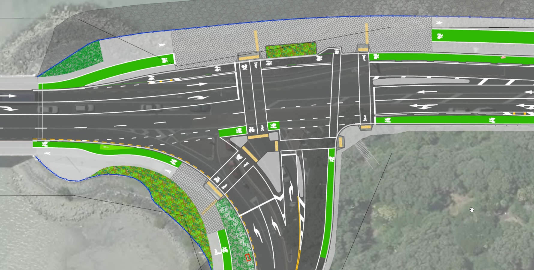
This includes making sure that the central island provides enough space for people waiting. At a rough guess, the design that was consented at the end of last year allows for approximately 8 bikes on the island. We feel it can be increased a bit more, especially by making more of the light gray area (see image at right) into waiting space.
Its important to note that the design is still pretty high-level. There are no details from AT yet of how the boardwalk might look, or the exact form of the ramps and transitions at Orakei Road.
This allows you to provide input before these elements are tied down – for example, some locals from the area have queried whether kayaks will still be able to get into the bay under the boardwalk. Inputs like this – or our recommendation regarding slip resistance risks – will inform the final design.
Do head over to AT’s feedback form now to add your thoughts! And if you simply want to comment on the basics, scroll back up to our overview at the top of the page.
Open Days
Got more questions? Ask them in the blog comments, or meet up with Auckland Transport at one of the two open days below:
- Wednesday 20 September, 7am to 10am at Lilliputt Mini Golf car park, 3 Tamaki Drive, Parnell.
- Saturday 23 September, 8am to 11am at Orakei Bay Village 228 Orakei Road, Remuera.


