November and December are very busy months for all of us – including Council, Auckland Transport, and thus Bike Auckland. With so much going on, and limited time to take it all in, here’s a quick roundup of what’s happening in the City Centre.
Downtown (& Quay Street) Ramped Up
Auckland is embarking on an ambitious redevelopment programme for its central waterfront, between Princes Wharf and Commerce Street (just east of the Ferry Terminal). While many of these upgrades have been signalled for a while, Council has called for them to be in place for 2021 – in time for the 36th America’s Cup, the APEC Forum, and Te Matatini.
That’s just three years. So there’s a lot of change coming, fast. First is the reconstruction of the seawall underlying the area next year. Then in 2020 come new ferry terminals, cruise ship facilities, public plazas, two new bus interchanges at the western and eastern ends – and a significant revamp of Quay Street in between.
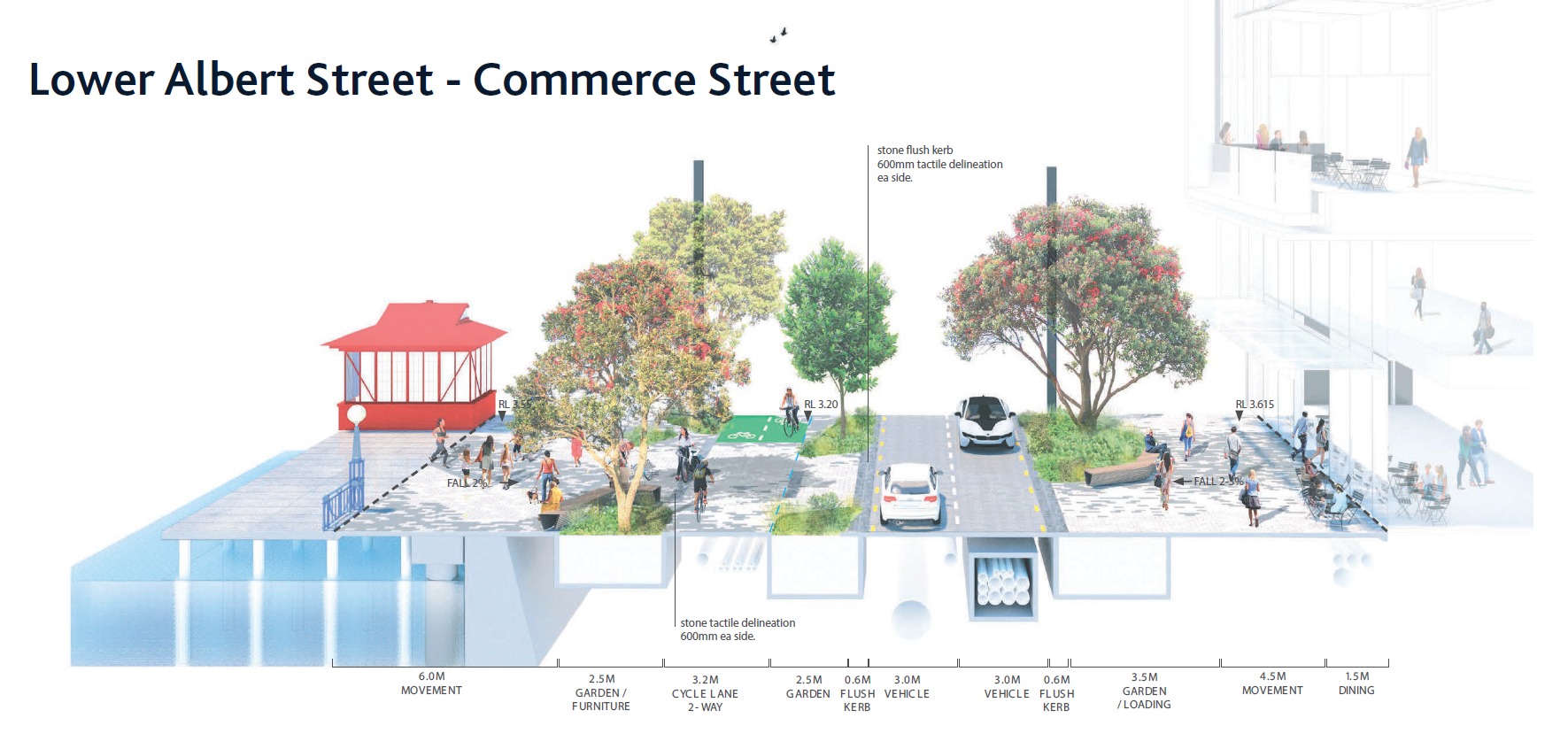
The change to Quay St will be most important for people on bikes, and Council’s designers are under high pressure to get a great new design sorted in the next couple of months. Key features we already know about:
- Reducing four lanes of traffic to two, from Lower Albert Street to Commerce Street
- Dedicated bus lanes between Lower Albert Street and Lower Hobson Street
- Increasing pedestrian space (with the new width coming from the removed car lanes)
So, what about the Quay Street Bikeway, the city end of Auckland’s busiest bikeway, Tamaki Drive? Over a thousand riders daily – and some days, over two thousand – want to know!
The first benefit: significant reduction of car traffic through the area. Bringing Quay St down to two lanes will “throttle down” the maximum volumes. Along with the coming changes to speed limits etc (see more below) and fewer trucks to the ports, riding on-road will also be less dangerous in the surrounding streets.
As for the core element: the bikeway design is not yet complete. But we know that it’ll be retained as a separated path for bikes only – AND it will be maintained throughout construction, although it may shift around a bit). The key item for discussion and design work internally at AT at the moment is what form the separation from pedestrians will take. The designers have been tasked with creating a plaza-like feel for the waterfront, with a street that pedestrians can easily cross, whether at or away from traffic lights – with only two lanes of traffic, and significant crowds, the latter has to be expected.

So how to avoid the design becoming another Beach Road Stage II failure, where the bikeway effectively becomes a shared path, because pedestrians are hardly aware of its status, and are constantly surprised if someone approaches on two wheels?
Bike Auckland has provided input into the design process, and though we’re not able to talk about it publicly yet, we are cautiously optimistic. The design team understands the concerns well. Indeed, the urban design is led by LandLab, who as designers of the upcoming Karangahape Road design, are well aware of the reasons for (and benefits of) separation.
The central section of Quay Street’s bikeway may not quite end up looking like K Road’s, but our insistence that both pedestrians and people on bikes deserve a clear distinction between their relative spaces seems to be treated seriously.
In the meantime, you can get more detail on the project website (here) or see a shorter version in a glossy brochure (here) – and then go and give feedback here before Sunday 23 December.
It’s worth saying “Make sure there is good, clear separation on Quay St between bikes and pedestrians!” and by all means ask for lots of (sheltered) bike parking, public hire bike facilities and scooter parking.
The Slow-down: Slowed Down
By now, we should have been well into consultation on safer-speed 30 kph zones in the city centre and a number of other town centres across Auckland. However, the brakes have been put on the process: as reported, the AT Board has asked management for more detailed information, including the communications strategy, with a view to consulting in the New Year.
The deferral seems to hinge on the question of whether reducing speeds to 30 kph iz appropriate for arterial roads in the City Centre like Fanshawe Street or Hobson Street, and whether this can be well communicated – both in the consultation, and on the streets. The delay is a worry, considering the level of bloodshed on our roads. Reducing speeds is the one “magic move” that works for everyone – whether on foot, bike or in vehicles.
One silver lining, perhaps, is the chance for a greater level of positive engagement (and more preparation) in the New Year., once we’re clear of this busy period. We certainly hope that the delay provides an opportunity for AT to come back with stronger designs for traffic calming those big arterial roads, rather than a watered-down 40 kph speed limit or similar.
Cook Street Bikeway Delayed
Remember Victoria Quarter’s “Surprise Bikeway” (plus pedestrian and safety improvements), set to bring new protected bike paths and new crossings on Cook Street and Union Street down to Victoria Street West?
Well, turns out that costs have climbed, after AT scoped the cost of associated moves (like re-configuring the motorway off-ramp), and included the higher streetscape quality expectations that tend to be normal post-Grey Lynn*. The budget is now substantial enough to require a more formal business case to achieve approval and ensure that AT gets value for money from the proposal.**
So the project has now been delayed into the next financial year, and won’t start before mid-2019 at the earliest.
*This is our guess as to why costs have risen compared to initial estimates. AT simply doesn’t seem keen on “cheap and cheerful” bikeway and pedestrian improvements anymore. Whether you agree with that, or whether the implications for tactical urbanism frustrate you…
**…the good news is that the initial response from the funding authorities is that the project looks very promising (i.e. provides benefits significantly exceeding the costs), even with the higher investment now required. This is partly, we are told, because the project will have substantial benefits in supporting the 30 kph city centre zone. Win-Win!
K Road Upgrade About to Break Ground
Here’s some real sunshine on the horizon – the Karangahape Road bike lanes are coming! The project has now gone out to market for construction companies, and is expected to start work in the early months of the coming year.
At the recent Lightpath Festival, Auckland Transport showed a big printed map of the project with the latest designs, including bringing protected intersections right into our City Centre!
Another treat in these designs: the Symonds Street slip lane onto K Road is gone. We’re told that because of the large numbers of buses on Symonds Street, drivers wanting to turn left were not really getting any benefit in reality. So instead of keeping the slip lane around for old times sake (or putting the zebra crossing on a raised table, the next-best option), AT decided to remove it altogether.
Similar changes – with even greater safety benefits for pedestrians – have also led to the removal of the two slip lanes at the Queen Street/ K Road intersection, though AT notes there’s still a little more work to do there to ensure the bike lanes aren’t too limiting for pedestrians.
Bikeway upgrades for better walking! Which leads us to…
Access 4 Everyone – Traffic Zones and a Car-Free Queen Street
Led by Auckland Council’s Urban Designers, Councillors last week unanimously voted to proceed with an ambitious plan to prioritise people movement over vehicle movement in the City Centre.
The plan is called “Access for Everyone” (A4E), to clarify that in the end, the changes will indeed benefit everyone – including those who still need to drive.
The concept is set to be fleshed out more, including trial schemes in 2019, but in effect Councillors voted in principle to:
- Pedestrianise Queen Street, and some other streets (bikes and public transport will still be permitted), even before further moves such as Light Rail, making these streets so much easier to travel on by foot and bike, and ensuring that buses e.g. City Link don’t end up slower than walking.
- Create a number of “traffic zones” in the “motorway ring” of the City Centre, where motor vehicle traffic travels between local cells by going around the City Centre, instead of through.
Our friends at Greater Auckland have more detail, and a strong take on what the approval means.
In a nutshell, these changes will make walking, cycling and public transport the primary modes for getting around and across the area, and will prevent unnecessary through-traffic, leading to an expected 20% drop in traffic on city streets. In the long run, this technique (borrowed from places like the Netherlands) will create space – both physical space and head-space – to allow other transport modes to bloom even more than they already do. It will help the City Centre become not just a more pleasant place for everyone to visit and travel in, but also a more fitting and pleasant place for the many tens of thousands of people who live here 24/7.
And that helps all of us – because the fewer people drive by car to the centre of our city, the less noise, pollution and traffic is created on the way on our urban and suburban through-roads.

These are all very exciting plans – with the potential to be truly transformative. The next move is to make sure they don’t get watered down or slowed down. For now, this collection of plans and projects about to start confirm that our city can indeed agree on bold moves towards the future.


