Back in October 2015, Auckland Transport appealed for local intelligence on better biking around Glen Innes, Pt England, and St Heliers. This was the first of their new-style community consultations, complete with an online map widget, an area-wide leaflet drop, and a decent amount of advertising and outreach.
The results have now been released (see the official page here), and they make for very interesting reading. There were a total of 1336 different suggestions for making the area more bike-friendly (overview here), via 260 hard copy feedback forms and 33 online responses.
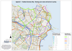
Here’s the summary area map, showing where people want to cycle, and the barriers/issues that are putting them off. The map also shows how often each route or barrier/issue was mentioned. Click to enlarge.
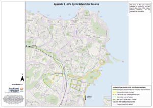
And here’s the planned Cycle Network for the area. Delivery is planned in two phases.
- Phase one is what’s already funded or fundable, to be built by 2018.
- Phase two is currently unfunded and will be implemented as funding becomes available, in 2019 and beyond.
AT adds: “Phase 2 projects are yet to be prioritized, and their delivery will depend on future funding availability. The cycle network presented on the map is AT’s desired network of cycle routes for the area.” (Again, click to enlarge.)
Some initial observations, via our Eastern correspondents:
- The big picture shows significant changes from the old Auckland Cycle Network. This is a win for practical feedback from people who really cycle! Some new routes reflect current preferred cycling routes – and following cyclist desire lines makes this projected network much more convincing than the old ACN – but we still have question marks over some choices.
- Most of the local cycle network as shown is currently unfunded and not due for construction before 2019; moreover, no priority is currently given (i.e. all proposed network roads are shown as having equal importance). Presumably there’ll be opportunities for feedback on the staging of these routes.
- You may have noticed that Tamaki Drive is not marked as an existing bike facility (it’s pink for ‘future/unfunded’), even though it is a cherished and high-profile cycling route of long standing, with a shared path on the sea side and on-road markings. We’re told this was a judgement call to reflect the fact the current form is not the final one; the long-term intention is to improve existing facilities on Tamaki Drive.
- Also, Merton Road is shown as an existing facility, but to our eyes the existing ‘shared-path’ infrastructure (one side of the road between College Rd and Felton Matthew) is of dubious standard.
- The funded/ confirmed projects are focused on connections to Glen Innes Station and a loop around GI/ Wai o Taiki Bay. We look forward to more detail about the blue dotted lines, what kind of facilities these will be, and how, for example, they’ll integrate with the GI to Tamaki Shared Path and the self-explaining roads.
- We’re also keen to hear more about the timing and design of the Greenways projects (Local Board initiatives) through Colin Maiden Park and out along Maybury Reserve to Pt England and beyond.
If wishes were horses we’d be galloping all the way home all over this map – but clearly it will take a while for funding and construction to meet the growing demand for better biking in this part of the city.
In the meantime, it’s great to see how real-life input has refreshed AT’s thinking in this area, and it’ll be interesting to see the next steps in deciding the next priorities. Maybe what’s needed next is a dedicated bike burb to keep the local focus strong…? More news as it comes to hand!
