The six-kilometre Ara Āmio i te Pokapū Tāone, City Centre Loop is an elongated circuit of cycleways and shared paths which runs from the waterfront to Te Ara i Whiti, the Lightpath and back down Grafton Gully and past the universities. Off it run key routes leading to landmark destinations like Pukekawa Auckland Domain, or heading out of the city centre, like the Northwestern Path.
But the Loop was a disparate collection of six mismatched projects which weren’t easy to navigate. The work to link them through best practice wayfinding design has resulted in a world class set of design guidelines which will reach well beyond the Tāmaki Makaurau City Centre.
Have you tried the City Centre Loop? Let us know what you think at the bottom of this article.

Emme Jacob remembers the moment when she realised the City Centre Loop project had made her a bike nut. She was looking back at GoPro footage of herself, a green novice on Tāmaki Makaurau Auckland’s cycleways, testing out routes as a newbie. It’s a far cry from the frequent rider she is today. The footage shows her getting lost more than once – and to her embarrassment – falling off her bike.
It was a vivid example of how challenging navigation can be for people who are less confident on bikes.
Luckily Emme wasn’t hurt and was keen to keep going with the project. She laughs remembering the footage from its early phases. But seeing those early excursions is an effective reminder of the people she is designing for. That’s because Emme is a wayfinding designer at Maynard, the advisors used by Auckland Transport to help make the City Centre Loop, and the arterials leading to it, easy to navigate.
“I fell into this project by being the least experienced cyclist in the team,” she says. “We needed a guinea pig to see how the pre-existing wayfinding was working for less confident people on bikes. What eventuated, was the opportunity to reimagine the system for ‘cycle considerers’ – whilst being a cycle considerer myself.”
The origins of the City Centre Loop project

Bringing the Loop into existence was the brainchild of a group at Auckland Transport. Mark Lenaarts, Wayfinding Product Owner, is a member of that group. He saw huge wins from small connections to link up the loop into one cohesive experience.
Mark is a long-term thinker with a bold ambition for Tāmaki Makaurau, and you can tell he’s absolutely passionate about what he does. Connecting up the City Centre Loop and giving it really optimal signposting are just the nuts and bolts of a much bigger vision.
At the start of this project, the City Centre Loop’s infrastructure was mostly in place. But the six cycleways and shared paths which make up the six kilometre Loop were built at different times and they look different from each other.
- Te Ara i Whiti / Lightpath (affectionately referred to as the ‘Pink Path’ by many)
- Grafton Gully
- Beach Road
- Quay Street
- Project Wave
- Nelson Street Cycleway
Mark explains:
“We knew that visitors and locals alike had difficulty navigating the city centre’s cycleways. The route wasn’t seamless.”
The Loop needed wayfinding signage. More than that, it needed an identity – a way of entering into the consciousness of Aucklanders.
Wayfinding signage


While some rules existed around how Auckland Transport does cycleway signage, they were inadequate to the work ahead. That’s where the work began for Emme and her colleague Sam van der Weerden.
Emme and Sam looked at best practice from elsewhere – but not all cities are navigated in the same way. A bespoke solution for Tāmaki Makaurau Auckland was needed. Empathy interviews with Aucklanders helped to uncover what matters to people, and where the frustrations lie. The Maynard team created draft signage and installed it to observe how it worked in situ. Test users biked the area with GoPros to test the signage.
“This has been a wider team effort with Eke Panuku and Auckland Council with valuable feedback from Waitematā Local Board, Heart of the City, City Centre Residents Group, Auckland Transport’s Māori Policy and Engagement Team, Bike Auckland and many others,” explains Mark. “And most importantly, it has been co-designed with customers during customer testing to ensure this works well for the people of Tāmaki Makaurau and visitors.”
Aha moments
There were many ‘aha!’ moments along the way. They unearthed insights such as:
- Existing signage heights are ‘outside the cone of vision’ of a person on a bike – current guidelines place them at the same height as car signage, 2.1 – 2.4 metres.
- You don’t just need signage before a junction. Taking a wrong turn is easily remedied (and less stressful) with signs after the junction which reaffirm which route you’re on.
- Including fun elements such as the rainbow flag for Karanga-a-Hape draws people into using the map.
- Even after just one exploratory ride around the signposted routes, people on bikes began to notice the signage, with its distinctive branding, earlier.
Sam’s masterstroke was reimagining the Loop as a circle with spokes in a diagrammatic map reminiscent of the London Tube map. Removed from the nitty gritty of the topography, viewers can immediately grasp the linkage between places, and the utility of the Loop for reaching their destination.

The landmarks on the map aren’t just roads and transport interchanges. The map notes city attractions too, as do the rest of the signage.
Mark from Auckland Transport explains:
“This is more than just signage, it’s regenerating and bringing people to the city centre. It connects attractions. Giving the Loop an identity helps to reveal and celebrate it as our flagship route.”
Emme continues:
“Imagine a future where locals and visitors alike can hop on a bike and feel confident finding their way to where they want to get to in Tāmaki Makaurau. The City Centre Loop unlocks city experiences.”
Many design iterations later, the team have developed a comprehensive suite of signage.

Colour and hierarchy of information
You’ll see the attractive dark blue and vivid green beacons, plinths, panels, maps and other signs around the city centre. The blue is Auckland Transport’s signature wayfinding colour. Studies show that people recognise and look out for signs in this colour. The bright leaf green stands out boldly from the dark blue base. Auckland Transport uses this green for active modes. (Other modes have their own colours, like yellow for public transport.)
There’s a clear hierarchy of information on the signage – those who aren’t stopping their bike can read the large letters at the top, and there’s more detail for those who want to stop and plan their route. Colourful elements of fun and strong consistent branding draw the viewer in. The visual vocabulary will be easily understood without needing to speak English or te reo Māori.
It’s a best practice library for urban planners, tailored to our unique region, and it’s world class.
The City Centre Loop Identity
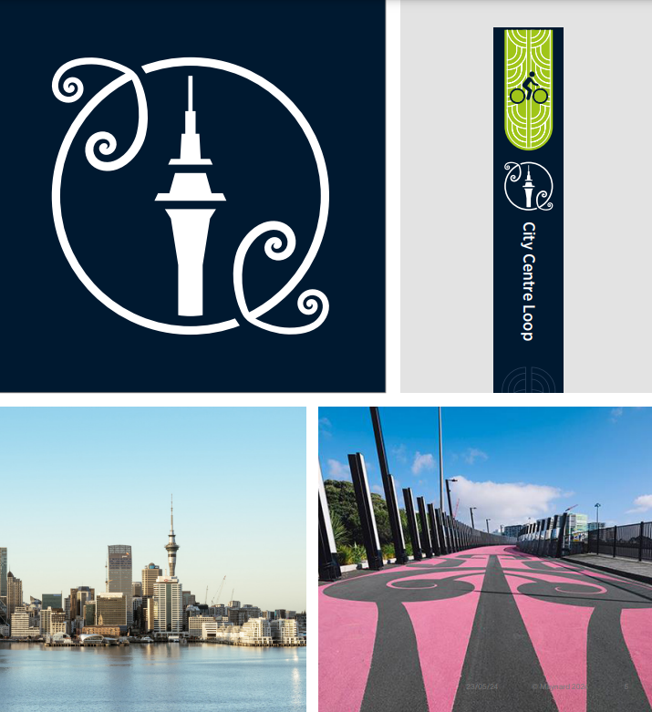
Those who have ridden Te Ara i Whiti, the Lightpath, will have noticed its beautiful traditional mangōpare / hammerhead sharks kōwhaiwhai design representing strength and determination. The original artist, Katz Maihi of Ngāti Whātua Ōrākei, was involved in the use of the symbol of Te Ara i Whiti for the identity of the City Centre Loop.
Two mangōpare circle another landmark in the City Centre Loop design: the Sky Tower. So often used for wayfinding, and an iconic visual for downtown Tāmaki Makaurau Auckland, it made sense for the Sky Tower to be part of the identity of the City Centre Loop.
Prominent on signage, and also marked on the ground, the Loop symbol is already a recognisable navigation tool for people on bikes.
The future: beyond the City Centre Loop

With the signage already installed on much of the Loop, Auckland Transport are now working to complete the remaining portion. Mark hopes it will go further however.
“It’s an improved design suite that will, I hope, benefit projects all over the region. We’ve come so far with listening and learning what works for people on bikes in Tāmaki Makaurau. We want to see it get used beyond the City Centre Loop. We want to see what we’ve created here rolled out as the new standard.”
As Mark describes his future vision, the excitement sizzles in the air. What if all key routes had an identity? What if anyone could hop on a bike and know they could find their way to where they want to go? Could Tāmaki Makaurau become a key destination for bike tourism, and a dream region for bike lovers to live in?
Did you know?
- 1 in 20 people coming into the City Centre in the mornings is on a bike.
- There are 5,000 trips on the City Centre Loop each day.
- Cycle trips in Tāmaki Makaurau Auckland have grown by 10% annually.