Here’s the guts. Auckland Transport is currently consulting on connecting the bottom of the Nelson St cycleway to the waterfront. And they need to do it before December 2020, because… America’s Cup.
The design is fine, as far as it goes. But it only goes halfway!
Why? Because… America’s Cup, budget, and time. Can’t afford the “disruption”. Can’t afford the full route. And there’s not enough time to build the full connection (which has been ready to go for the last two years) because… America’s Cup.
This leaves a gap on the map that means:
- more and more people on bikes and scooters will be squeezed through the busy restaurant area of the Viaduct Basin…
- …which will be jammed with more and more people, because… America’s Cup.
THE GOOD NEWS: we can see a tactical way to solve this conundrum. But we need your voices, loud and clear, to help AT out of this pickle and make a good design even better.
Use our quick 1-2-3 summary and smash that big pink button NOW to let AT know they can do this, and that our support is conditional on them delivering the full route! And scroll down for more details and the background.
Add your voice before Sunday 8 March!
Let AT know you’ll support the project on these conditions:
- Please “ungap the map” with a tactical extension to Quay St via Lower Hobson St as per Bike AKL’s design
- Reshape the crossing at the south end, to make it safer and save a tree, as per Sam Hood’s smart suggestion
- And give the new Market Place bikeway a strong kerb, distinct enough to stop cars from parking on it
(Plus of course anything else that’s important to you!)
Here’s the project page, with maps and plans. AT’s project team will be hosting two drop-in sessions to discuss the project:
Tuesday 3 March 2020, 12pm to 2pm – Sierra Cafe, 48 Market Place, Auckland Central
Saturday 7 March 2020, 9am to 11am – Sierra Cafe, 48 Market Place, Auckland Central
What’s the background?
December 2015: Phase 1. Lightpath opens, with a section of protected cycleway on Nelson St as far as Victoria St. The plan is to extend this safe route to the waterfront, linking into the Quay St cycleway and the rest of the network.
Mid-2017: Phase 2. The Nelson St protected cycleway is extended down the hill to Fanshawe St and just into Market Place, as far as Pakenham St East, completed by December 2017.
At the same time, AT is finalising a design for Phase 3, and is confident enough to plan publicity material about how great it will be for families to be able to ride safely and uninterrupted from the pink path to the waterfront.
September 2017: AT consults the public on the design for Phase 3: a two-way bikeway on Market Place, continuing past the Tepid Baths on Customs St West, and through Lower Hobson St to Quay St. We – and the public – said “Great, build it!”
We also said, “This connection finally extends the promise of Lightpath all the way to the harbour.”
And then, for over two years: crickets.
The current consultation
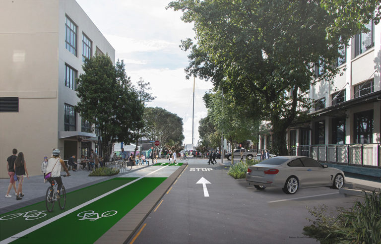
February 2020: AT is now consulting again on that final section – but only half of it: the two-way bikeway through Market Place, with raised tables (and bike/walk crossings) at the intersections at both ends.
Market Place will become one-way for vehicles in this section, with all the current parking shifted to the eastern side of the street. The plan is to have this built by December 2020, which is great.


What’s the problem?
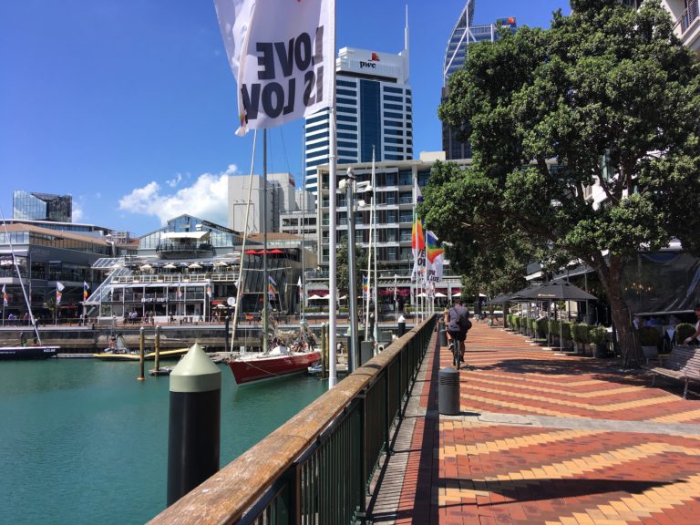
By stopping short of the full connection to Quay St, the current plan will pour a rising flood of people on bikes and scooters directly into the Viaduct Basin “shared path” (which is more sort of a brick plaza and dining area), right when crowds gather for the America’s Cup.
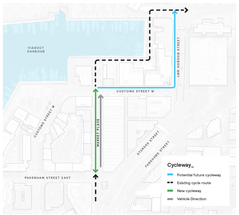
Here’s the 2017 map of the planned route via Lower Hobson St. Note the tidy green zig-zag that takes it around the outside of the Viaduct precinct, rather than right through the busy restaurant area.

And here’s the current situation. Spot the blue “potential future cycleway” – now two full degrees of separation away (including new investigation and fresh consultation) from “finally extending the promise of Lightpath all the way to the harbour.”
What?! Why only half the route??
Here’s what AT told us:
Customs Street West and Lower Hobson Street cycling connections will be investigated post AC36 [America’s Cup], and weren’t able to be considered prior due to constraints around time, budget, and disruption to traffic.
Frankly, we’re unimpressed:
- Will be investigated post America’s Cup?? Close on four years since it was first designed and consulted on?
- Time constraints?? Now? Two and a half years after consultation, with the America’s Cup on the horizon the whole time?
- Budget constraints?? Forgive us but that rings hollow in a week where AT and Council have celebrated the fact that a billion dollars is being spent on getting the central city up to scratch, transport-wise.
And as for “disruption to traffic” – this is something Aucklanders can all agree on, but a necessary part of making travel safer and smoother for all. People walking and biking are traffic, too – and delaying this link will prolong disruptions to their safety and access.
We also asked how the Viaduct restaurant area was expected to handle the rise in small-wheeled traffic that inevitably comes with new infrastructure, amongst the crowds expected over the summer of 2020/ 2021. Here’s what AT told us:
This route is a designated shared path. We encourage all road users to share with care and it is expected that cyclists will respond accordingly in a slow speed shared path environment. We will also be looking at what we can do to make the path through the viaduct better for riders. Safety and wayfinding signage has been strategically integrated into the project scope.
Can we fix it? Yes we can!
We know you’re hungry for answers at this point; and you know we don’t take this stuff lying down. In fact, this is exactly the sort of challenge that makes us sit up and get busy thinking of solutions.
Having seen the way it’s possible to widen footpaths on High St overnight – and how a tactical bike lane was built on Federal Street using planters and plastic armadillos – we are asking AT to raise their game and apply the same tactical urbanism in the soon-to-be-very-busy Viaduct area.
We have agreement in principle that this should be done, but we need your strong support to get it over the line.

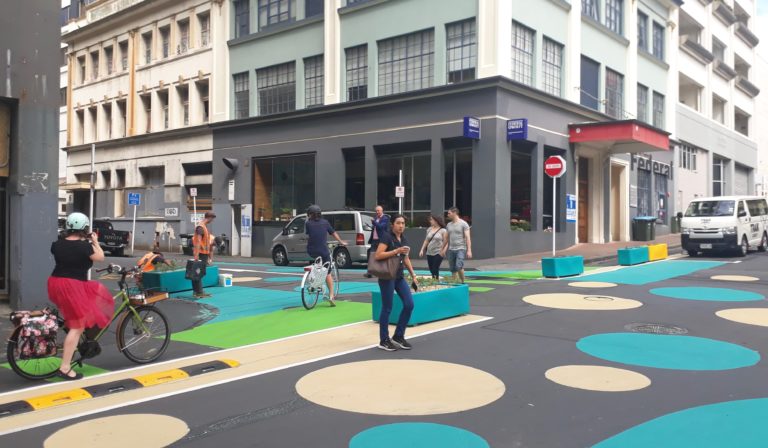
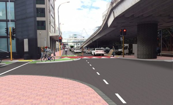
Below, we’ve sketched up an option for Lower Hobson Street that creates a wider path, along a route that’s going to be a lot less busy with pedestrians. We’re putting this in AT’s hands for detailed design, including smart traffic-calming and whatever it takes to safely bridge the gap along Customs St West as well.
Obviously we’ll be looking for non-slip surfaces, excellent signage and smart use of paint to make this route intuitive to new users, and strong protection from passing traffic and would-be bike lane parkers.


Meanwhile, back on Market Place…
The design for Market Place is great, but we’re asking for two fixes here.
Firstly, we’d like to confirm a robust treatment on the edge of the two-way bike path, strong enough to deter people in vehicles from using it as parking or loading space.
Secondly, we support a redesign of the crossing at the south end as suggested by Sam Hood on Twitter. Sam’s proposal is overlaid in red on the AT design, below. Realigning the angle bike paths and the crossing, plus narrowing the entrance to the one-way part of Market Place, provides:
- better traffic calming
- reinforces the one-way section for vehicles
- doesn’t force people on bikes through two 90-degree bends
- adds a degree of bike-calming at the crossing, for those headed towards the Viaduct
- saves a tree (the dotted green circle)!

Right. Ready to have your say? Get in before Sunday 8 March!
Let AT know you support this project on these conditions:
- Please “ungap the map” with a tactical extension to Quay St via Lower Hobson St as per Bike AKL’s design
- Reshape the crossing at the south end, to make it safer and save a tree, as per Sam Hood’s smart suggestion
- And give the new Market Place bikeway a strong kerb, distinct enough to stop cars from parking on it
(Plus of course anything else that’s important to you!)


