[Update: this consultation has closed. But you can have your say on the Local Board Priorities before Wednesday 28 March 2018, and ask what greenway projects the Otara-Papatoetoe Local Board will prioritise for delivery!]
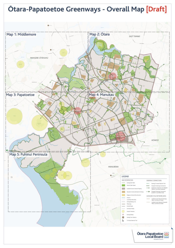
Now that the Local Path Design Guide is out in the wild, it’s going to be exciting to see what the Local Boards of with it. First out of the gate is the Otara-Papatoetoe Local Board Draft Greenways Plan, with some seriously ambitious long-term visioneering.
Having grown up biking in this part of town, I love the way the Local Board is embracing the huge potential. These burbs are nice and flat, with heaps of parks and green spaces and alleyways that can be hooked together via quiet streets and protected cycleways. I’d love to see the kids of the future roaming as freely as my siblings and I did – on foot and on bikes, from shops to parks to train stations to local library to school to skate-bowl to friend’s houses and home again.
The draft plan is currently up for consultation until 8 January 2017. It’s a busy time of year, so grab a second to look at the close-up maps and draft network plan, see what you think, and send in your thoughts.

This is big picture thinking – with a timeframe of decades – so let’s start with a great big YES PLEASE in principle. Even if you don’t live locally, you can absolutely support a Local Board that’s aiming to maximize active transport and local links over the coming years. (Plus, we can always chuck our bikes on the train and go exploring!)
And of course, if you’re familiar with local streets that would make great greenways, by all means share that detailed knowledge.
Here’s the page again, with links to maps, the big plan, and the survey. Add your voice!
And here’s a preview of the feedback form questions, so you can get your thoughts in order before clicking through.
First there are a few some demographic questions about you; then four general statements you can agree or disagree with as strongly as you like:
- I support the creation of a Greenways network for the Otara-Papatoetoe Local Board area.
- The proposed Greenways routes shown on the accompanying map are in the right place
- Creation of more local or improved walking and cycling links through reserves and quiet roads will encourage me to cycle and walk more.
- If more local or improved walking and cycling links are created through reserves and quiet roads, I am likely to use these to get to work, school, recreational facilities or shopping.
And then three open-ended questions:
- Are there any other routes or projects not listed that you think should be included?
- Over the next 3-5 years, which routes would you like to see prioritised in the area? [We suggest starting with routes to schools, shops/libraries, and train stations… i.e. attractive and visible destinations, used daily. Socially ‘catching’ routes like these are really good for encouraging a community to get back onto bikes.]
- Do you have any other comments or suggestions on the draft Greenways Plan?
Note: Greenways through parks, along waterways, and on quiet streets are part of a bigger picture that also includes protected bike lanes on main streets (although Local Boards can work with AT to make main streets a priority, as for example with the Mt Albert town centre revitalisation plan). So it’s excellent to see this draft network connecting people to and through the town centres, as well as via back routes and green spaces. Go Otara-Papatoetoe Local Board!


