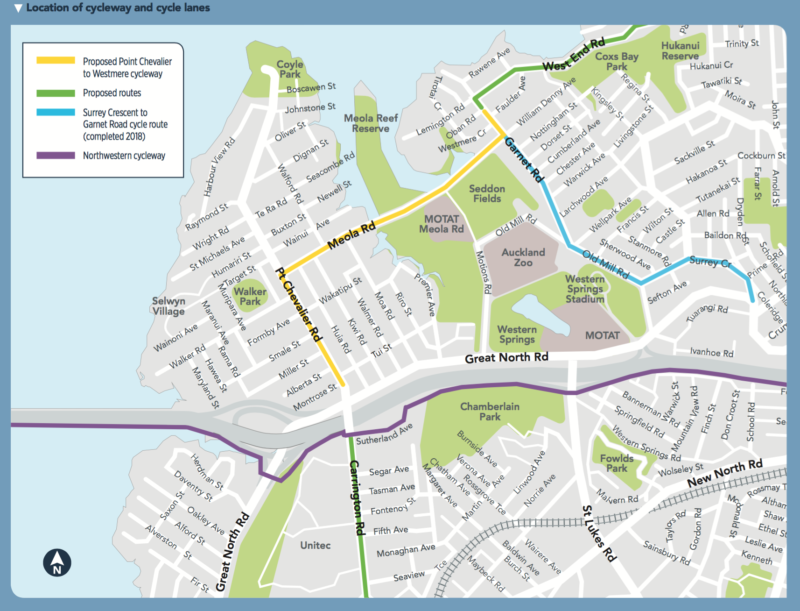
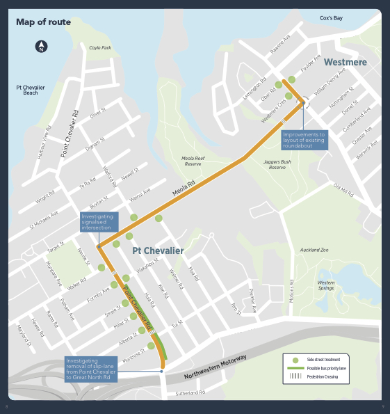
Consultation is now open on proposed walking and biking improvements from Pt Chevalier to Westmere, specially from the Pt Chev shops to the Garnet Rd shops via Pt Chevalier Rd and Meola Rd. Auckland Transport plans to deliver this project by the end of 2018.
Feedback is open till Sunday 23 April 2017 (direct link to feedback form here; but we recommend you check the detailed plans on the project page first, and read our thoughts below). Also, there will be two public info sessions:
- Saturday 8 April, 10am – 2.30pm at the Pt Chevalier Library
- Wednesday 12 April, 5 – 8pm at Nomad Restaurant @ the Pt Chev shops.
This is an exciting extension of the inner city cycling network. As well as connecting locals to the Northwestern Cycleway and the Grey Lynn route to the CBD, the new bike lanes link two town centres and a couple of major sports fields – plus there are four schools and a kindy and a huge retirement village along the way.
Like the Grey Lynn routes, this is a model for how major ‘backbone’ cycleways feed into neighborhoods and vice versa. And with the nearby Waterview Connection on the verge of opening, more and safer local travel options will be all the more important.
So what’s proposed? Before getting into the specifics, there are several walk/bike/public transport features to get excited about:
- Protected bike lanes along Pt Chevalier Rd to Meola Rd
- Protected bike lanes on Meola, plus one-way ‘shared paths’ (likely demarcated for pedestrians and bikes)
- Raised crossings on side-streets, which will hugely enhance the walking experience and bike safety
- Two new zebra crossings, plus an existing zebra will be signalised
- A possible bus priority lane on Pt Chevalier Rd, southbound from Wakatipu St to the town centre.
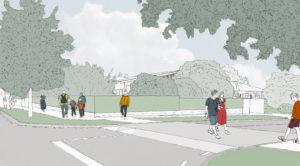
And, in terms of general street safety:
- New traffic signals at the Pt Chev/ Meola intersection (currently a very hairy Give Way that does no favours to anyone, especially people on bikes or on foot)
- The Meola/Garnet roundabout gets a makeover
- And the slip lane outside the Pt Chevalier Library may also go.
AT notes there will also be some relocation of bus stops, reconfiguring of parking spots, and some trees on Pt Chevalier Rd will be re-planted or replaced.
Section 1: Pt Chevalier Rd from Great North Rd to north of Wakatipu St
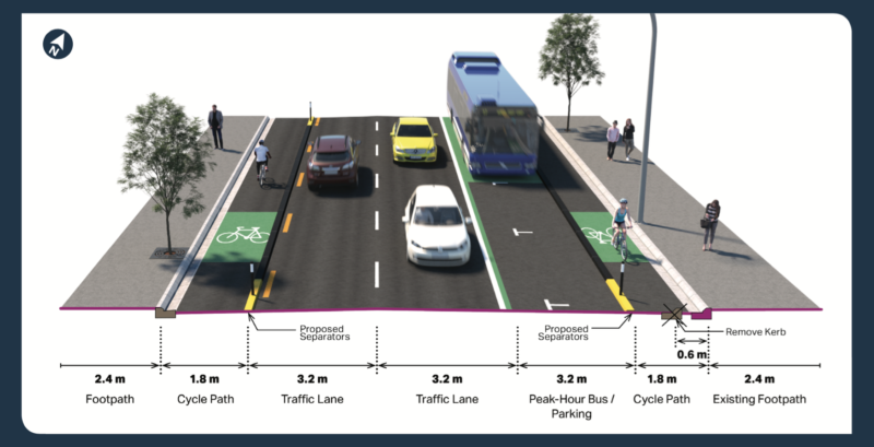
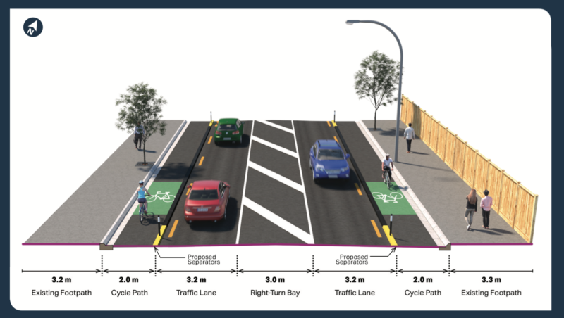
Protected bike lanes on both sides, and raised crossings at side streets. The painted median stays for right turns into Tui and Montrose; otherwise, removed.
An afternoon peak bus priority lane on the east side is being investigated (with parking allowed at all other times on the east side). Parking disappears from the west side. If the bus lane goes in, the zebra crossing between Alberta & Tui will be upgraded with signals, because more than two lanes of traffic is too much for a zebra.
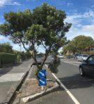
Some trees will need to be relocated along this section and up to Meola Rd. As you know, we love trees, and we’re keen to see more, larger, and healthier specimens beautifying this beach boulevard. Many of the existing ones are struggling, alas, and aren’t having the full traffic-calming effect originally intended when they were planted roughly a decade ago.
The good news is, the project team has stated that they will provide new and relocated trees with bigger and better tree pits – and, because the trees will be next to a bike lane rather than cars or buses, they can have wider branches. This will improve the walking experience, help create a gateway feeling around local shops, and bring shade in coming decades.
Section 2: Pt Chev Rd, from Wakatipu St to Walker Rd
The protected bike lanes continue, as do raised crossings at all side streets. The painted median goes, and the bus lane doesn’t go all the way to Walker, which means parking can stay (outside the bike lane) on the east side of the street, where the shops are, but is removed from the west side.
A new pedestrian crossing will go in at the shops, likely north of the Wakatipu Rd intersection. We think the shops could benefit from more and better bike parking to supplement the on-street parking.
Section 3: Pt Chev Rd, from Walker Rd to Meola Rd
The protected bike lanes and raised side-street crossings continue. The painted median returns, to accommodate high volumes of right-turning traffic at the Meola Rd intersection (this is a heavily tidal route to the city by those avoiding the motorway and Great North Road). This means parking will need to be removed from both sides of the street north of Walker Rd.
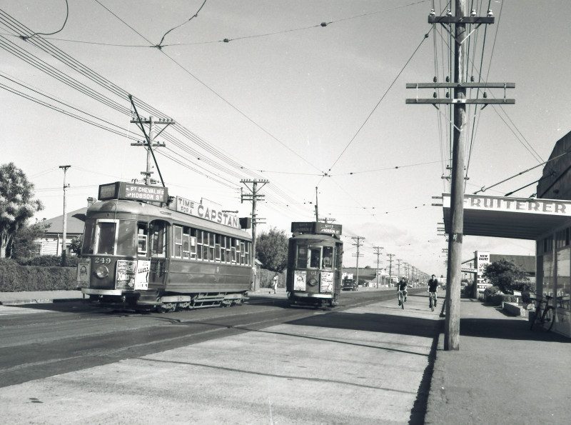
We foresee potential issues for the small set of shops just north of Walker Rd. There’s a popular pizza parlour and sweet cakery opposite a wig salon (whose clients include chemotherapy patients) and a tiny grocer. This is a historic tram stop, hence its ‘gathering spot’ vibe, with shops flanking both sides of the road, and these businesses enjoy a decent amount of local custom via foot, bus, and bikes (and could definitely use more bike parking). However, the current proposal means customers arriving by car would have to park further down Pt Chev Rd or around the corner on Walker Rd.
We’re eager to see the design accommodate everyone’s needs as cleverly and compassionately as possible. It’s a tight squeeze here, with extra demands placed on it by the right turn into Meola. We suspect more detailed design work will need to go into this section, including the intersection, to ensure all locals can confidently support it.
The design for the Meola Rd intersection is still being finalized. The current proposal is for traffic signals, intended to make things safer for people on bikes and on foot, especially those tricky right turns. Some possibilities:
- advance signals for bikes
- ‘hook turns’ (i.e. two-step turns) for right-turning people on bikes
- holding left-turning traffic out of Meola so that people on bikes can safely turn right from the bike lane
Another thought for this section: how will bike traffic continuing up Pt Chevalier Rd manage after the traffic lights? Especially school kids on bikes, with the primary school three blocks north. There’s a small set of shops on the west side just north of the Meola intersection. Our sense is that kids will likely revert to the footpath here, rather than risk riding in the door zone. (NB This is out of scope for the current project, but ideally the design would account for this somehow.)
Section 4: Meola Rd from Pt Chev Rd to the Meola Reef Dog Park
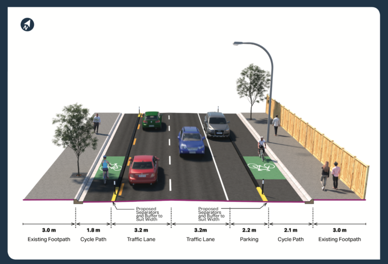
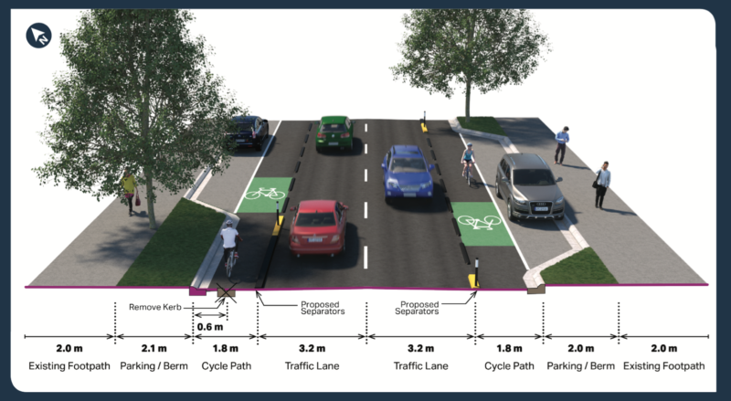
Given the tight space and the mature trees (which will stay!), the road will be widened slightly to the north to accommodate protected bike lanes on both sides, with indented parking as shown in the image below.
The parking here is on the ‘wrong side’ of the bike lanes, so we’ll suggest the designers look at flipping the scenario (which may lead to a ‘weave in, weave out’ scenario around driveways and trees, not quite ideal either). In either case, the number of car parks is relatively small.
Raised crossings are added on all side streets, and the existing zebra crossing remains. All good, as this is a crucial link for school kids – which raises the question of school and kindy links northward and southward. (We see a strong case for a Local Board Greenway project here!).
Section 5: Meola Rd, from Meola Park to just after Seddon Fields
Anyone who’s travelled this road knows it’s as tight as an inappropriate agricultural metaphor – and also that there’s currently no footpath on the north side.
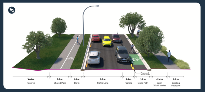
The proposal adds a shared path along the northern berm, although ‘shared path’ is a bit of a misnomer here because the ‘shared’ sections are bookended by protected one-direction bike lanes, which means the vast majority of bike users will be heading eastward on the path. As shown in the image below, this will allow the path to be separated (by paint) into bike and walk sections. So, compared to many other urban shared paths, this should work reasonably well.
On the south side, a protected on-road cycleway preserves the existing footpath (dappled and delightful!) for pedestrians. There will also be a short section of shared path on the south side between the MOTAT 2 entrance and the driveway to the Seddon Fields parking lot. (Q: Will there be enough car parking for soccer – or is will the safe new connections through Pt Chev and Grey Lynn make a Bike to Soccer initiative suddenly not just possible, but highly attractive?)
Across the Motions Creek Bridge, both sides will have shared bike/walk paths, as it’s simply too narrow for anything else. (The roadway will be narrowed a bit to accommodate the shared paths on the bridge, which should help with traffic-calming).
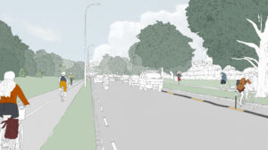
Through this section, all on-street parking will move to the southern side of Meola Rd (outside the bike lane), leaving a 5.3m two-way roadway, which is wider than the current situation with parking on both sides!
All trees will stay, and the works along here will coincide with scheduled maintenance, which should minimize the disruption/reduce costs, and allows for relocation of lights and services as necessary.
Section 6: Meola Rd, from Seddon Park to Garnet Rd roundabout
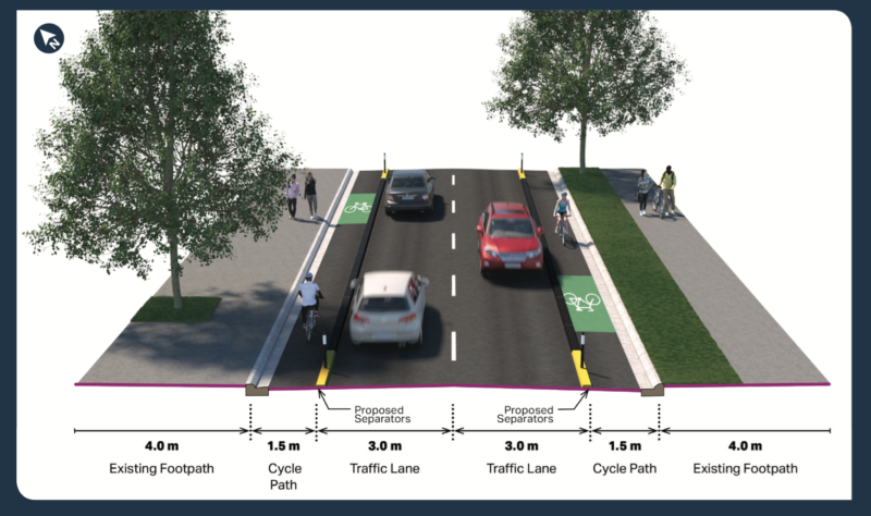
This is the steepest section of the route (local journalist and bike chap Russell Brown has dubbed it the ‘Meola Rd Gravitational Anomaly’). Once safely off the narrow Meola Creek bridge, the bike lanes revert to protected on-road lanes, leaving the footpaths for pedestrians. This section will have no on-street parking.
Also, the existing pedestrian refuge outside the Sea Scout Hall will become a proper zebra crossing, befitting its crucial connection of the walking path through Jaggers Bush / Western Springs Park, and the new Westmere Coastal Boardwalk.
Section 7: Garnet Rd roundabout to the shops
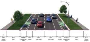
Still with us? Good, nearly there! This last section takes you through to the Garnet Rd shops, with bike lanes protected from traffic by physical barriers and/or parked cars, and raised side street crossings for pedestrians.
The Garnet Rd roundabout will become a single-lane roundabout, with safety improvements for all modes of travel, including a proper zebra crossing across the top of William Denny, which is a major route for Westmere Primary foot and bike traffic.
And that’s about it. Have a look at the project page for more details, and let us know what you think below.
We’re excited about these improvements to a neighbourhood that already sees heaps of bike and foot travel by people of all ages, and has the potential for even more. Point Chev is historically a cruisy bike-and-tram seaside burb – won’t it be great to see that vibe come round all over again?
Remember, feedback closes Sunday 23 April.
