Auckland Transport is currently consulting on the proposed traffic signals at Ngapipi Road / Tamaki Drive. This is one of the worst historical black spots for people on bikes in Auckland. It’s also a major intersection on our busiest cycle route, with some ~1,000 riders a day even in the middle of winter.
First, let’s recap the many objectives – and constraints – the design has to contend with. It needs to:
- Improve safety and convenience for people on bikes. Especially – but not only – those turning here, and those heading directly to town who currently have to merge westbound with fast traffic from Ngapipi.
- Improve safety and convenience for pedestrians. Currently, there are barely any pedestrian crossing facilities here – only a pedestrian refuge some 70m to the east.
- Work with the new Tamaki Drive cycleway between Quay Street and this intersection, on the way as part of the Urban Cycleway Fund. NB this is likely to be a two-way cycleway, like Quay Street – but whether on the north or south side of Tamaki Drive has not yet been agreed!
- Work with the existing narrow bridge to the west of the intersection – OR work with a potential addition to the bridge or a future full rebuild of the bridge. (The bridge redesign project has begun, and will hopefully be funded – but is not yet confirmed. More on the bridge issues later).
- Deal with the fact that – at least at the moment – riders are split relatively evenly, in both directions, between on-road cyclists and the off-road shared path. And that almost all of the off-road riders in both directions travel on the seaward side – because east of the intersection, there’s no off-road path on the landward side.
- Not require too much land reclamation. We understand Iwi are already sceptical about the degree of reclamation proposed. AT state that the ‘extra’ widening to the north (visible in their plans) is not about future-proofing for more car lanes, but instead related to the fact that the new bridge may eventually sit further north than the current one. (Presumably, the new bridge will be built in stages, so as to not create a situation where Tamaki Drive is closed for many months while the old bridge is demolished and a new one is built).
- Allow for the over-dimension vehicle route from Ngapipi Road to Tamaki Drive and the Port of Auckland.
- Preserve the row of older Pohutukawa trees on the water side of the southern approach of Ngapipi Road.
- Not impact on the cliff face that creates the eastern / southern boundary of the intersection.
- Achieve sufficient vehicle throughput to convince the higher ups in AT – and the car-driving folk of the Eastern Bays – that the new design won’t cause massive gridlock.
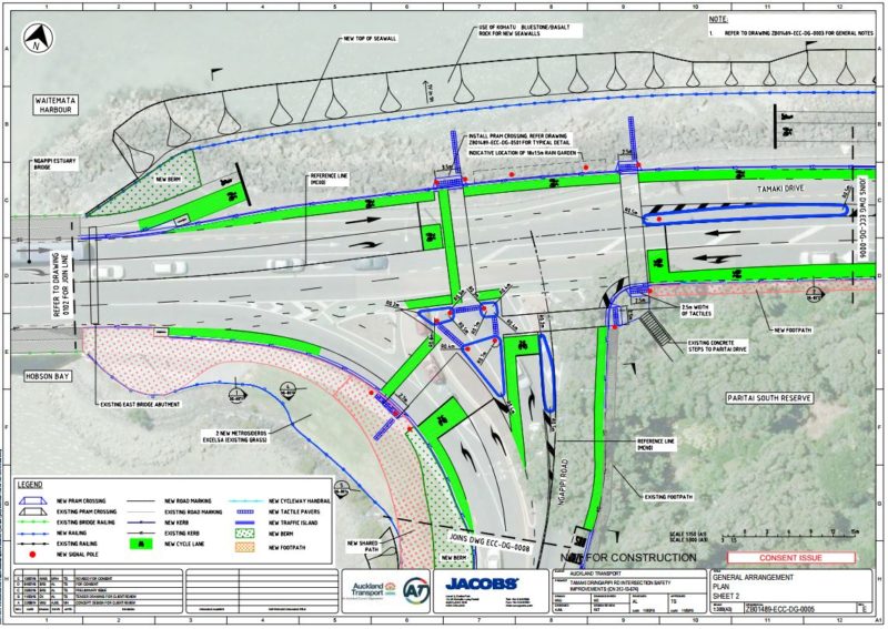
Faced with all of the above requirements, here’s what Auckland Transport has come up with:

It’s fair to say that this design hasn’t found full favour with the wider cycling community. Transportblog ran two articles about it, the first calling it ‘a hot mess‘, and the second proposing an alternate design from a reader. We’ve also heard concerns from our own networks.
Key worries with the current proposal
- The design is too complex and busy – not easily ‘readable’ by people using it.
- Cyclists would be unnecessarily held up, either by the signals, or by the proposed ‘shared path’ sections north of the intersection.
- The right turns in particular remain very problematic – both from west to south, and south to east.
- Particular anger was reserved for the ‘bike advance boxes’ and the little mini-approach cycle lanes from the south, including the fact that a rider might have to cross two slip lane traffic lanes to turn right from Ngapipi.
- The fact that the slip lane was not only still there, but widened to two lanes. There have been calls to ‘pull it into the signals’ – i.e. remove the triangular island altogether, not just signalize it.
- The lack of protection for the on-road cycle lanes – just another ‘paint only’ design.
- It’s bad practice to provide different facilities for two types of user groups – i.e. ‘on-road for confident riders’ and ‘off-road for less confident riders’; it was felt there should should be one type of bikeway here, good enough for both the sports rider and the family outing on bikes.
- There’s so much space being used (and created), especially on the northern side – and yet not enough good use is being made of it. Some have questioned whether this was because Auckland Transport was reserving land for extra car lanes in the future.
Bike Auckland has intentionally held back before blogging on this. A group of five of us (including three regular riders of the route) considered the design – and the early criticisms made – and then met with Auckland Transport. We had a long discussion with them about the design, and what could be improved.
During the meeting, and in subsequent emails, AT reiterated the constraints we noted at the beginning – and we questioned them on a couple of key points.
1. Mixed facilities
Do the constraints really mean AT can’t combine the on-road and off-road facilities into one treatment for all kinds of cyclists? Why not build wide protected one-way cycle lanes each side OR a protected two-way path on one side, and be done with it? Sure, these will need to tie in with whatever will soon be built west of the intersection to connect to Quay Street Cycleway – but surely AT can coordinate that?
The issue, it turns out, lies east of the intersection. The Tamaki Drive Masterplan proposes a protected two-way cycleway along the sea-side – like what’s currently outside the Quay Street ferry terminal, but extending all the way along the bays. Awesomeness.
But that plan currently sits unfunded. As far as we know, it’s not even an empty line item on a budget sheet anywhere. This means nobody knows what will happen for cycling east of the intersection – and even less, when.
Getting to the current point with this single intersection has taken around 6 years. It might take at least that long again before we see the full waterfront cycleway built.
Or maybe it will only be a few short years – because numbers continue to grow along this route, and biking is becoming ever more popular, and there’s now a local push to consider the whole boulevard, which means we might see more budget and more willingness to remove road parking to make the space work better for all.
We might. But we don’t know. And it certainly won’t happen in time to design this intersection to match. (Unless as a city we want to park this intersection upgrade for now, and say ‘Let’s fix this when we fix the whole road.’ Do we really want this? Bike Auckland doesn’t, given how dicey this stretch is for people on bikes right now).
So the intersection design will simply have to deal with this fact for now: Roughly half the riders ride on the path. Roughly half ride on the road.
This isn’t (just) a split of ‘confident’ and ‘less confident’. It’s not even just about ‘faster’ and ‘more relaxed’ cycling. If the intersection had only one set of facilities (EITHER protected one-ways OR a two-way on one side), this would create major inconvenience and/or safety problems.
Why? Some proportion of all riders (roughly 25% if we assume the on-road riders and off-road riders are each 50% of the total) would always be ‘on the wrong side’ when it comes to getting where they need to go next. They’d need to switch to the other side to continue – and, if there’s only one type of bike facility through the intersection, they’d have to do this somewhere on the open road once past the intersection. (The opportunity to add signalised bike crossings makes the intersection the best location for a cross-over point, if one is going to be needed).
Therefore, we reluctantly agree that continuing for now with two sets of bike facilities makes some sense. However, we are seeking improvements (discussed further below).
2. Removal of the slip lanes
So what about the slip lane from Ngapipi Drive to Tamaki Drive? Can that not be removed and the slip lane brought into the intersection – “squared up” as per the Transportblog proposal?
AT responded to this query, in part, with:
During the option assessment stage, we evaluated the possibility to “square” off the intersection. Due to the need to accommodate bus and semi-trailer tracking (for the public transport and over-dimension routes), this would result in a much larger intersection footprint and longer crossing distance for pedestrians. Additional reclamation would be required (around 1000m2 in excess of our current proposal) and it would be challenging to tie back in with Ngapipi Estuary Bridge. We have optimised the design by keeping a slip lane arrangement but having it signalised.
Auckland Transport showed the tested layout to us. Their alternate design retains the two left-turn lanes shown in the first image of this blog, which are designed for very large vehicles (for the overdimension route to the port) – a key difference from the design shown on Transport Blog. This, in turn, does indeed lead to a much larger intersection, with very long pedestrian crossings (from memory, the west-east crossing was ~25m) and a greater ‘bulge’ of extra land reclamation to the north. It’s doable maybe, says AT; but it’s not supported.
This could be overcome by having only a single left turn lane – but this is something AT resists, as it feels that this would mean that car traffic from Ngapipi in particular would back up severely. Or it could be achieved by removing trucks from the equation (something that’s not an option for the Port, nor for the overdimension network).
Considering that the initial crop of formal submissions on the current design apparently included some saying ‘Build a roundabout instead!’ and several others saying ‘Don’t change anything, the intersection is fine as it is!’, AT is not proposing to make such changes to the slip lanes. They feel these would make the design unviable and un-consentable. (And although they did not say so, we suspect that the project managers also worry about ‘word from on high’ telling them to back off, should they actually propose to make such changes).
So, what CAN be improved?
Given we still want a better design, where does all the above leave us? We raised a number of improvement options with AT:
- Protection & widening of on-road lanes: If we need to keep split facilities for the interim until the cycleway to the east is built, we want AT to consider ways of improving the on-road lanes in both directions. Ideally, with a form of protected cycle lane, and with greater width than in the design AT are now seeking submissions on. AT responded that this might be doable, and that they will be looking at options for either raised lanes (maybe with a Franklin Road design allowing cyclists to enter and exit more easily), or concrete protectors as along Quay Street or Carlton Gore. We noted that if a physical protector design is chosen, this needs to be made wide and safe enough – we are aware that some faster / sports riders are concerned that physical protectors, especially if ‘suddenly appearing’, can be a risk. But if designed right, they will also raise the quality of the ride through here, and protect riders from turning vehicles.
- ‘Through green’ for cyclists: On Quay Street, AT have implemented a nifty feature where the cycleway west and east gets a green even if cars are stopped at a red – as long as no pedestrians have called the crossing over the cycleway. This will likely be possible here too, says AT – which would make eastbound riding especially more convenient.
- Avoid on-road riders crossing through the shared path area: Especially if 1 and 2 can be done, there will be much less need for on-road riders to cross the shared path to get off-road and detour past the traffic signals, which the current design allows with the little ramps just east of the bridge. It may be safer to then remove these.
-

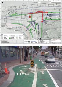
Layout of the proposed new signalised “jug handle” crossing, and an example from San Francisco (Photo copyright SFMTA, flipped around for our left-hand driving). A bit more storage space for bike groups wanting to turn would not go amiss for Tamaki Drive, though! From West to South turns: Add a new north-south cycle crossing with a “jug handle” pocket: To make it safer and easier to cross into Ngapipi, eastbound cyclists would be provided with a dedicated space to wait outside of the through cycleway (on the north side) before getting a separate north-south cycle crossing on the eastern side (AT’s current design only has cycle crossings on the western side). AT feels this should be doable. Be gone, ‘advanced stop box’.
- From South to West and from South to East: Add a dedicated bike lane on the Ngapipi Road approach: AT did not add this previously, as the protected Pohutukawa constrain this. However, we noted that the ~5m shared path proposed to the WEST of the Pohutukawa could be changed to a ~3m footpath and ~2m wide dedicated bike lane, leading to the western cycle crossings (and west along Tamaki Drive). AT considers this likely doable. We will be discussing the best way of separating walking and cycling, as we would prefer something stronger than just cobbles or similar (as used on Upper Queen Street bridge). We will also discuss with AT the best way of ensuring that this dedicated path is suitable and attractive for faster riders.
- South to East: Remove cycle feeder lanes, and widen crossings and island instead: We suggested that the small approach cycle lanes be removed (riders can use the dedicated bike path as per 5 above). This will allow the green cycle crossings to be widened, and the island to be made larger. Together with 5, this will provide a much safer, more readable way for a rider approaching from the south to turn right (though it will still need two signals – first to cross the slip lane, then to cross Tamaki Drive).
As noted above, AT feels that many of these items appear doable. However, so as to not prejudice the public consultation process and consent hearing, they’ll only make these decisions after they have received all feedback on the public consultation.
So this is where you come in. There will likely be healthy dose of ‘It ain’t broken (for cars), so don’t fix it’ in the feedback. To counteract that for the benefit of people on bikes, we encourage you to add your own support – or constructive criticism! – to the AT design. So please do. Consider our own 6 improvement suggestions above, and what you feel needs changing, and submit!
Feedback closes Friday September 23rd.
Here’s the AT project page. Because it’s a resource consent, you need to make your submission via the Auckland Council website, as follows:
- Find the list of current projects here, and scroll down to Ngapipi Rd.
- Copy the application numbers (R/LUC/2016/3297, R/REG/2016/3298, R/REG/2016/3299, R/REG/2016/3307 & R/REG/2016/3493) and then…
- Click through to the submission form, paste the application numbers in, and off you go.


